Draft Analysis
A parcel-based analysis of conservation value using the following weighted variables. The darker the parcel shading, the higher the conservation value. The variables can be changed and were used mainly to illustrate the potential process.
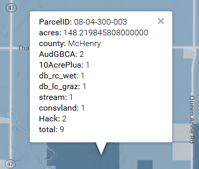
AudGBCA - 3 types of Grassland Bird Conservation Areas(GBCAs) occuring in the Nippersink Watershed. Parcel weighted 1, 2, or 3 from lowest to highest conservation value if intersecting with a GBCA. If parcel intersected by more than one GBCA, the higher weight is given.
10AcrePlus - If the parcel is 10 acres or larger, weighted 1.
db_rc_wet - If parcel intersects with this layer (row crops with high wetland potential), weighted 1.
db_lc_graz - If parcel intersects with this layer (grazing land), weighted 1.
stream - If the parcel intersects with a surface water record from the National Hydrography Dataset (stream or pond), weighted 1.
consvland - If the parcel is within 1000 feet of a record from the Prairie State Conservation Coalition's I-View database of conservation lands or a Wisconsin Dept of Natural Resources parcel, weighted 1.
Hack - If the parcel intersects with Hackmatack National Wildlife Refuge's purchasing boundary, weighted 2.